
Geotaria · Bahamas
Bahamas: distretti (secondo livello)
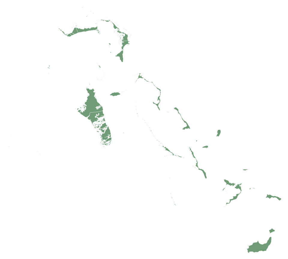
Nomina distretti sulla mappa di Bahamas e riempila.
Informazioni sulla mappa
Questa mappa di Bahamas ha 33 elementi (distretti). Scrivi i nomi a memoria in qualsiasi ordine: ogni risposta corretta colora la mappa.
Niente installazione o registrazione: premi Inizia e scrivi. Con un account salvi i record e puoi sfidare un amico 1 contro 1.
Bahamas — capitale: Nassau; popolazione: 403.033 (2025); superficie: 13.943 km². Nessun confine terrestre.
Domande frequenti
Quanti elementi ci sono su questa mappa di Bahamas (distretti)?
Questa mappa di Bahamas ha 33 elementi (distretti).
Bahamas: quali sono le distretti?
Acklins, Berry Islands, Bimini, Black Point, Cat Island, Central Abaco, Central Andros, Central Eleuthera, City of Freeport, Crooked Island and Long Cay, East Grand Bahama, Exuma, Grand Cay, Green Turtle Cay, Harbour Island, Hope Town, Inagua, Long Island, Mangrove Cay, Mayaguana, Moore's Island, New Providence, North Abaco, North Andros, North Eleuthera, Ragged Island, Rum Cay, San Salvador, South Abaco, South Andros, South Eleuthera, Spanish Wells e West Grand Bahama.
Bahamas: il numero di distretti in ogni regione
Acklins: 1; Berry Islands: 1; Bimini: 1; Black Point: 2; Cat: 1; Central Abaco: 3; Central Andros: 1; Central Eleuthera: 1; Crooked Island: 1; East Grand Bahama: 1; Freeport: 1; Great Inagua: 1; Long Island: 1; Mangrove Cay: 1; Mayaguana: 1; Moore's Island: 1; New Providence: 1; North Abaco: 2; North Andros: 1; North Eleuthera: 2; Ragged Island: 1; Rum Cay: 1; San Salvador: 1; South Abaco: 1; South Andros: 1; South Eleuthera: 1; Spanish Wells: 1; West Grand Bahama: 1.
Devo scrivere i nomi esattamente?
Maiuscole e accenti non contano. Basta una parola intera se identifica una sola regione; i frammenti non valgono.
Bahamas: primo livello (32) · Bandiera: Bahamas · Bahamas: bandiera, mappa, capitale e dati · Geotaria
Distretti in cifre
| Nome | distretti | Popolazione | Superficie (km²) |
|---|---|---|---|
| Acklins | Acklins | 692 (2022) | 482 |
| Berry Islands | Berry Islands | — | 46 |
| Bimini | Bimini | — | 27 |
| Black Point | Black Point | — | 3,8 |
| Cat Island | Cat | — | 353 |
| Central Abaco | Central Abaco | — | 411 |
| Central Andros | Central Andros | — | 1124 |
| Central Eleuthera | Central Eleuthera | — | 121 |
| City of Freeport | Freeport | — | 69 |
| Crooked Island and Long Cay | Crooked Island | — | 323 |
| East Grand Bahama | East Grand Bahama | — | 564 |
| Exuma | Black Point | — | 288 |
| Grand Cay | North Abaco | — | 14 |
| Green Turtle Cay | Central Abaco | — | 7,8 |
| Harbour Island | North Eleuthera | — | 2,7 |
| Hope Town | Central Abaco | — | 15 |
| Inagua | Great Inagua | — | 1677 |
| Long Island | Long Island | — | 429 |
| Mangrove Cay | Mangrove Cay | — | 372 |
| Mayaguana | Mayaguana | — | 300 |
| Moore's Island | Moore's Island | — | 20 |
| New Providence | New Providence | 274.400 (2016) | 223 |
| North Abaco | North Abaco | — | 224 |
| North Andros | North Andros | 5133 (2010) | 2555 |
| North Eleuthera | North Eleuthera | — | 109 |
| Ragged Island | Ragged Island | — | 29 |
| Rum Cay | Rum Cay | — | 86 |
| San Salvador | San Salvador | — | 156 |
| South Abaco | South Abaco | — | 639 |
| South Andros | South Andros | — | 943 |
| South Eleuthera | South Eleuthera | — | 206 |
| Spanish Wells | Spanish Wells | — | 6,3 |
| West Grand Bahama | West Grand Bahama | — | 332 |
Superficie: geoBoundaries. Regione, capoluoghi e popolazione: Wikidata; tra parentesi l’anno di ogni dato sulla popolazione.
Altre mappe: Americhe
- Antigua e Barbuda
- Argentina
- Barbados
- Belize
- Bolivia
- Brasile
- Canada
- Cile
- Colombia
- Costa Rica
- Cuba
- Dominica
- Ecuador
- El Salvador
- Stati Uniti
- Grenada
- Guatemala
- Guyana
- Haiti
- Honduras
- Giamaica
- Messico
- Nicaragua
- Panama
- Paraguay
- Perù
- Repubblica Dominicana
- Saint Kitts e Nevis
- Saint Vincent e Grenadine
- Saint Lucia
- Suriname
- Trinidad e Tobago
- Uruguay
- Venezuela